General description
Pitch and roll, collectively referred to as tilt, is one of the first sensors to check. This tells whether the instrument is level or not. All Nortek instruments have a sensor measuring tilt that has been calibrated during production. Values of pitch and roll are given in degrees. The difference is that the former is rotation about the Y-axis, and the latter is rotation about the X-axis. For an instrument looking straight upward, pitch and roll are defined to be 0°. When an instrument is turned over and points straight downwards, the pitch will still be 0°, while the roll is 0° for traditional liquid level and solid state accelerometer tilt sensors and +/- 180° when an AHRS is installed.
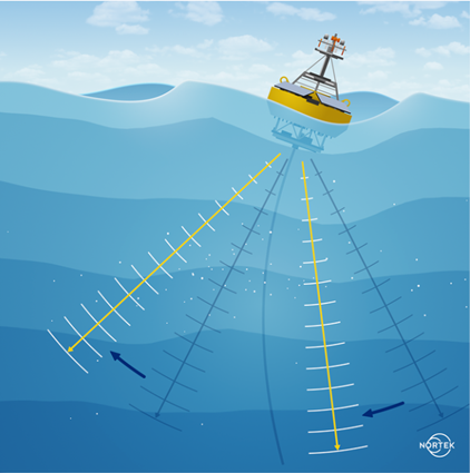
Ideally, instruments should always have 0° (or 180°) of tilt during a deployment. This will often be difficult, especially with buoy-mounted instruments that move with water. Bottom-mounted frames on uneven ground and massive currents or waves displacing an instrument are also common reasons leading to tilt. To compensate for uneven sea floor, it may be beneficial to use a gimbal. The gimbal uses gravity to keep the instrument upright, so it is necessary to have a counterweight underneath the instrument. Extra weight on the frame can also to some extent reduce the risk of being displaced by massive currents or waves. Whatever reason causes the tilt, pitch and roll lead to several unwanted consequences, such as depth change of cells, thickness increase of sidelobe interference, and changes in the direction of measured velocities.
Data analysis
Figure 1 shows an example of how a sudden excessive tilt may appear in the data. Here you can see that the average signal strength is affected by the tilting. The big change in pitch shows that the instrument is almost completely turned upside down. Bad data due to the instrument being tilted is not always as visually obvious as this, especially when tilt is not as extreme, so you must always take a closer look at the data in periods when pitch and roll are significant and varies a lot. When the tilt exceeds 5 degrees it is recommended to carry out thorough quality control measures and consider reprocessing the data. When the instrument tilt exceeds 20-25 degrees the range of the instrument is reduced and the data begins to degrade in ways that are not recoverable. The user should always strive for an installation where the instrument is oriented vertically either towards the surface or downward in reference to mean water level. For information on preventing instrument tilt when mounting or deploying the ADCP, in-depth guidelines can be found in the Operational Guidelines. The most typical effects of tilted instruments include depth change of cells, increased sidelobe interference and changes in the direction of measured velocities, all of which are discussed below. In addition, this article discusses options available during data processing.
It is important to note that the limits given should be considered as guidelines and it is the end users responsibility to apply proper quality control measures for all data and consider tilt effects for each individual deployment. In addition, the user should also be aware of the key differences between tilt sensor accuracy (given in the instrument technical specification) and velocity measurement accuracy.
Consequences of high tilt
Sidelobe interference
In addition to the horizontal shift of the depth cells, tilted instruments measuring near a boundary can experience an increase in sidelobe interference and a reduction in the effective range (see Figure 2). Sidelobe interference is due to energy "leaking" from the direction of the main lobe and interacting with the boundary before the main lobe. A boundary can be the surface, the seabed, or a physical object, all of which provide stronger returns than suspended particles. This will contaminate the received signal and make it difficult to measure velocities in this layer. When the instrument is pointing directly at the surface the angle of the slanted beams can result in sidelobe interference that may affect 5-10% of the velocity profile. When tilt occurs this effect will increase and reduce the range further. Unfortunately, it is not possible to reverse the effects of sidelobe interference in post-processing because the received signal is already contaminated. It is recommended to remove all of the data in the profile where this interference has occurred.
Centre beam
Unlike slanted beams, the centre beam is pointing directly toward the surface or sea floor and will therefore not be affected by sidelobe interference. Sidelobe effects will only occur in the centre beam if the instrument is tilted. In cases where the centre beam is used as an altimeter, valid data can only be achieved within a window of 10 degrees tilt.
Changes of measured velocity direction
If the instrument is configured to collect data in ENU coordinates, the velocity measurements will be corrected for instrument tilt*. The UP direction will always be perpendicular to the surface level. As long as the instrument compass is calibrated correctly and not disturbed by nearby magnetic objects, the East and North directions will be relative to the earth's magnetic field. Both BEAM and XYZ coordinates are relative to the instrument. When the instrument orientation changes, so does the orientation of these coordinate systems and the resulting Z-velocities will be relative to the instrument axis and the measured current directions will be changed accordingly. An example of the changes; the Z-axis and the Up-axis are aligned for instruments at level, but deviate when tilt is experienced. This is described in the article What is the difference between Z and Up? If the data collected cannot be presented in ENU coordinates, corrections for tilt in BEAM or XYZ coordinates will have to be done manually in post-processing.
💡 NOTE: The transforms from beam or XYZ to ENU (see Coordinate System) correct for tilt (and
compass) in the sense that the final coordinate system is aligned with the gravitational axis (and the
magnetic north pole). However, the data are not automatically corrected for the vertical mapping of the
cells (use cells at the same level) and for this reason, there will be residual errors in the current profile. How to correct for this effect is described in the following paragraph.
Impact on wave measurements
When studying waves using the central beam of the instrument - the altimeter functionality - the impact of a tilted instrument is significantly larger than on pure current measurements. Since the vertical acoustic pulse is reflecting from the surface the best response occurs when the pulse path is orthogonal to the surface from which it is reflecting. The return response deteriorates as the beam deviates from the vertical. Performance is notably reduced when the tilt exceeds 5 degrees, and the data can be considered completely unusable if the tilt exceeds 10 degrees.
QC measures - bin mapping
It can be difficult to avoid instrument tilt throughout the entirety of a deployment. In some cases the instrument rigging shifts or is installed at an undesirable angle due to an object or incline on the ocean floor. In cases of massive currents and waves high instrument tilt can periodically occur, displacing the instrument or mooring line. Minor periodic variations in pitch and roll can sometimes be averaged out and the corresponding velocities corrected, however, data with excessive tilt or permanent offsets in pitch or roll should be carefully monitored.
One of the key assumptions for velocity measurements using ADCP is that it that the flow is "horizontally homogeneous" - that is, at a given depth, the velocity is constant in the same direction across all the beams. A major consequence of tilted instruments is the change in depth cells or bins. The pointing angle of the instrument beams are consequently shifted, and the along-beam depth cells are no longer located in the same horizontal layer (see Figure 2). This may result in a "smearing effect" on the velocity data because the depth cells are incorrectly located at different levels in the water column. Velocity outputs from the same numbered cells will thus represent currents from different depths. Eventually, two differently numbered cells might be aligned to the same depth. With severe tilt and/or at great range, the difference in vertical position will become even bigger. Furthermore, if there is strong vertical shear in the water column, and the bins are moving in and out of regions with variable velocities the resulting velocity can be biased. Consequently, it is highly recommended to apply a remapping of the cells from the different beams to its proper vertical location to maintain a consistent profile. Depending on your instrument and deployment setup, there are processing methods available (discussed below) to correct for shift in cell position.
Generation 1 instruments (AWAC, Aquadopp, Aquadopp Profiler)
For the narrow band midlife instruments, remapping of depth cells can be done using the feature "Remove tilt effects" in the post-processing software Storm. This process will remap the depth cells and convert the velocity data to ENU if it is collected in BEAM or XYZ coordinates (see paragraph Changes of measured velocity direction). There is no option to remap the cells without converting to ENU. For midlife instruments, remapping of depth cells will be carried out on averaged data, because raw data is not available. This means that the remapping is most suitable for cases with static tilt. If the instrument has moved during the averaging period, "smearing" or bias effects in the averaged data must be considered.
Generation 2 instruments (AWAC, Aquadopp, Aquadopp Profiler)
For the Generation 2 instruments bin mapping is done automatically within the instrument on each individual ping, and data outputted is corrected for potential tilt.
Signature instruments
For Signature instruments, raw data used to make the average velocity data is available, and so correction can be carried out on each individual ping. The method is referred to as "Bin mapping" and is available in the post-processing software Ocean Contour. After performing bin mapping, the resulting velocities are only provided in ENU coordinates. This is because the repositioned cells are no longer in reference to the instruments orientation as they are in BEAM or XYZ coordinates.
For Signature instruments with an AHRS (Attitude and Heading Reference System) installed, replacing the traditional tilt sensor (and magnetometer), it is possible to enable real-time bin mapping on a ping-by-ping basis and have the output data in telemetry files given directly with depth corrections. However, bin mapping will never be executed in the provided raw data files. Without an AHRS, the output is never automatically corrected for, neither in telemetry or raw data.
Since remapped cells no longer will be in relation to the instrument head, the velocity data cannot be given in BEAM or XYZ coordinates after bin mapping. For that reason, the bin mapping procedure will also convert to ENU coordinates, if the data is not already in ENU coordinates. To clarify any misconceptions, transformation to ENU coordinates and bin mapping are two different things. To bin map, it is also necessary to convert to ENU coordinates, but data can be given in ENU coordinates without bin mapping. To carry out the cell position maneuvering, tilt is the only sensor directly required, but since the data after bin mapping must be given in ENU coordinates, the instrument also needs to have a compass that measures heading.
Updated